Breaking news: ACQUA CORRENTE SU MARTE !

E’ stato annunciato oggi ufficialmente dalla NASA (la conferenza è in corso) che sono stati individuati segni “evidenti” di depositi di acqua sul terreno marziano. I depositi individuati da MGS sarebbero più recenti di 7 anni e testimonierebbero che l’acqua su Marte potrebbe scorrere ancora in particolari condizioni.
Vista la temperatura e la pressione del pianeta l’acqua vaporizzarebbe all’istante ma se fosse espulsa dal sottosuolo in grandi quantità farebbe in tempo a fluire sul terreno per qualche km.

Qui ci sono le impressionanti fotografie:

questa è la pagina dedicata a Marte sul sito nasa.gov:
http://www.nasa.gov/mission_pages/mars/main/index.html

e qui un primo articolo, probabilmente ne seguiranno altri, la conferenza è ancora in corso:
http://www.spaceflightnow.com/news/n0612/06mgs/

Orpo orpo orpolina! Che spettacolo le foto … :smiley:
Attendiamo la fine della conferenza stampa allora!!!

ho letto la notizia sull’ansa,grande notizia :smiley:

Grande MGS! sono convinto che MRO non ce la fara’ rimpiangere pero’…

Ecco qual’era la notizia “major” che annunciavano qualche giorno fa con il comunicato stampa che sembrava il canto del cigno di MGS.
Paolo, a questo punto non possiamo che condividere la comune soddisfazione, con una pinta di birra offerta da te.
Mi pare il minimo.
A quando ? (così mi porto la copia del tuo libro e forse, dopo tanti tentativi, riuscirò a farmela autografare :grinning: )

A parte le idiozie che mi vengono spontanee, non pensate che a questo punto uno di questi siti dovrebbe essere la destinazione di una delle prossime missioni marziane con lander?
Immaginate che roba un “pinpoint landing” in una di quelle locazioni?
:scream:

Thread promosso come annuncio globale! :smiley:
Se lo merita!!

Il comunicato stampa ufficiale

Dec. 6, 2006

Dwayne Brown/Erica Hupp
Headquarters, Washington
202-358-1726/1237

Guy Webster
Jet Propulsion Laboratory, Pasadena, Calif.
818-354-6278

RELEASE: 06-362

NASA IMAGES SUGGEST WATER STILL FLOWS IN BRIEF SPURTS ON MARS

WASHINGTON - NASA photographs have revealed bright new deposits seen
in two gullies on Mars that suggest water carried sediment through
them sometime during the past seven years.

“These observations give the strongest evidence to date that water
still flows occasionally on the surface of Mars,” said Michael Meyer,
lead scientist for NASA’s Mars Exploration Program, Washington.

Liquid water, as opposed to the water ice and water vapor known to
exist at Mars, is considered necessary for life. The new findings
heighten intrigue about the potential for microbial life on Mars. The
Mars Orbiter Camera on NASA’s Mars Global Surveyor provided the new
evidence of the deposits in images taken in 2004 and 2005.

“The shapes of these deposits are what you would expect to see if the
material were carried by flowing water,” said Michael Malin of Malin
Space Science Systems, San Diego. “They have finger-like branches at
the downhill end and easily diverted around small obstacles.” Malin
is principal investigator for the camera and lead author of a report
about the findings published in the journal Science.

The atmosphere of Mars is so thin and the temperature so cold that
liquid water cannot persist at the surface. It would rapidly
evaporate or freeze. Researchers propose that water could remain
liquid long enough, after breaking out from an underground source, to
carry debris downslope before totally freezing. The two fresh
deposits are each several hundred meters or yards long.

The light tone of the deposits could be from surface frost
continuously replenished by ice within the body of the deposit.
Another possibility is a salty crust, which would be a sign of
water’s effects in concentrating the salts. If the deposits had
resulted from dry dust slipping down the slope, they would likely be
dark, based on the dark tones of dust freshly disturbed by rover
tracks, dust devils and fresh craters on Mars.

Mars Global Surveyor has discovered tens of thousands of gullies on
slopes inside craters and other depressions on Mars. Most gullies are
at latitudes of 30 degrees or higher. Malin and his team first
reported the discovery of the gullies in 2000. To look for changes
that might indicate present-day flow of water, his camera team
repeatedly imaged hundreds of the sites. One pair of images showed a
gully that appeared after mid-2002. That site was on a sand dune, and
the gully-cutting process was interpreted as a dry flow of sand.

Today’s announcement is the first to reveal newly deposited material
apparently carried by fluids after earlier imaging of the same
gullies. The two sites are inside craters in the Terra Sirenum and
the Centauri Montes regions of southern Mars.

“These fresh deposits suggest that at some places and times on
present-day Mars, liquid water is emerging from beneath the ground
and briefly flowing down the slopes. This possibility raises
questions about how the water would stay melted below ground, how
widespread it might be, and whether there’s a below-ground wet
habitat conducive to life. Future missions may provide the answers,”
said Malin.

Besides looking for changes in gullies, the orbiter’s camera team
assessed the rate at which new impact craters appear. The camera
photographed approximately 98 percent of Mars in 1999 and
approximately 30 percent of the planet was photographed again in
2006. The newer images show 20 fresh impact craters, ranging in
diameter from 7 feet (2 meters) to 486 feet (148 meters) that were
not present approximately seven years earlier. These results have
important implications for determining the ages of features on the
surface of Mars. These results also approximately match predictions
and imply that Martian terrain with few craters is truly young.

Mars Global Surveyor began orbiting Mars in 1997. The spacecraft is
responsible for many important discoveries. NASA has not heard from
the spacecraft since early November. Attempts to contact it continue.
Its unprecedented longevity has allowed monitoring Mars for over
several years past its projected lifetime.

NASA’s Jet Propulsion Laboratory, Pasadena, manages the Mars Global
Surveyor mission for the NASA Science Mission Directorate,
Washington.

For more information about NASA’s Mars missions, visit:

-end-

A parte le idiozie che mi vengono spontanee, non pensate che a questo punto uno di questi siti dovrebbe essere la destinazione di una delle prossime missioni marziane con lander? Immaginate che roba un "pinpoint landing" in una di quelle locazioni? :scream:

Ho paura che sarebbe piuttosto difficile. Purtroppo tutti i “gullies” si trovano all’interno di crateri, in siti dove sarebbe difficile atterrare e dove dovrebbero trovarsi abbondanti depositi di detriti. Una idea di cui leggevo di recente e’ quella di rover armati di veri e propri mortai che potrebbero sparare dei piccoli proiettili-sonda in queste colate di fango.
Per i frequentatori del forum che possono accedere alle biblioteche universitarie segnalo questo articolo: Garrick-Bethell, I., “Artillery Based Explorers: A New Architecture for Regional Planetary Geology”, Acta Astronautica, 57, 2005, 722-732

Ecco qual'era la notizia "major" che annunciavano qualche giorno fa con il comunicato stampa che sembrava il canto del cigno di MGS. Paolo, a questo punto non possiamo che condividere la comune soddisfazione, con una pinta di birra offerta da te. Mi pare il minimo. A quando ? (così mi porto la copia del tuo libro e forse, dopo tanti tentativi, riuscirò a farmela autografare :grinning: )

Magari all’inizio dell’anno si puo’ riprovare una gita al planetario…

Per i frequentatori del forum che possono accedere alle biblioteche universitarie segnalo questo articolo: Garrick-Bethell, I., “Artillery Based Explorers: A New Architecture for Regional Planetary Geology”, Acta Astronautica, 57, 2005, 722-732

Che fesso… una ricerchina sul web ha fruttato direttamente il pdf http://web.mit.edu/iang/www/pubs/artillery_05.pdf

Ecco qual'era la notizia "major" che annunciavano qualche giorno fa con il comunicato stampa che sembrava il canto del cigno di MGS. Paolo, a questo punto non possiamo che condividere la comune soddisfazione, con una pinta di birra offerta da te. Mi pare il minimo. A quando ? (così mi porto la copia del tuo libro e forse, dopo tanti tentativi, riuscirò a farmela autografare :grinning: )

Magari all’inizio dell’anno si puo’ riprovare una gita al planetario…

Letto, approvato e sottoscritto … :grinning:

Thread promosso come annuncio globale! :smiley: Se lo merita!!

Beh penso che se lo meriti tutto questa notizia! :smiley:

Questa è una NOTIZIA.
Direi che MGS ha concluso la sua carriera in modo più che degno!
Quindi: se l’acqua riesce ad arrivare in superficie con sufficiente pressione/quantità da fluire e creare dei “rivoli” prima di evaporare, nel sottosuolo ce ne dovrebbe essere in abbondanza giusto? E non solo nelle zone polari…

L’articolo sulla scoperta pubblicato sul numero odierno di Science http://www.sciencemag.org/cgi/content/short/314/5805/1573

Perdonate l’ignoranza: non potrebbero essere rivoli di “sabbia e massi” dovuti ad attivita’ sismica del pianeta? La certezza dell’acqua e’ dovuta a precise misurazioni della strumenazione di bordo della sonda?

E’ stata mai misurata l’attivita’ di sismica di marte?

PS: non e’ per fare l’avvocato del diavolo, mi son solo passate per la testa queste domande ieri sera e solo ora ho trovato il tempo di scrivere sul forum. Cheerio

Perdonate l'ignoranza: non potrebbero essere rivoli di "sabbia e massi" dovuti ad attivita' sismica del pianeta? La certezza dell'acqua e' dovuta a precise misurazioni della strumenazione di bordo della sonda?

E’ stata mai misurata l’attivita’ di sismica di marte?

PS: non e’ per fare l’avvocato del diavolo, mi son solo passate per la testa queste domande ieri sera e solo ora ho trovato il tempo di scrivere sul forum. Cheerio

Credo che i rivoli abbiano le caratteristiche di colate di materiale con la viscosita’ del fango, per cui si pensa che debbano essere formate da un miscuglio di “terra” e di qualcosa di liquido. Altre considerazioni portano a pensare all’acqua.
Riguardo all’altra domanda, le uniche sonde a portare dei sismometri su Marte erano i 2 Viking. Quello di Viking 1 si guasto’ subito e non fu possibile sganciarlo dalla sua struttura di protezione usata durante il volo. Quello di Viking 2 funziono’ perfettamente, ma siccome era montato sulla piattaforma della sonda (e non sulle zampe, come sarebbe stato il caso), registro’ un po’ di tutto. In particolare registrava qualunque oscillazione della sonda dovuta al vento, alla movimentazione del braccio robot, al registratore a nastro, ai vari attuatori ecc.
Nei primi mesi registro’ almeno un debole terremoto.
Credo, ma non ne sono sicuro, che il Mars 96 russo portasse dei sismometri, ma non ha mai abbandonato l’orbita terrestre.

Paolo, ti ringrazio per la veloce risposta :slight_smile:

Riporto su questo thread con un aggiornamento interessante sulla questione:

Media Relations University of California-Berkeley

Media Contacts: Robert Sanders
(510) 643-6998 / (510) 642-3734

Additional Resources:

Taylor Perron, (617) 495-4687
Michael Manga, (510) 643-8532
Mark Richards, (510) 642-5872
Jerry Mitrovica, (416) 978-4946

FOR IMMEDIATE RELEASE: Wednesday, June 13, 2007

Strong evidence that Mars once had an ocean

A paper in this week’s issue of Nature by University of California,
Berkeley, geophysicists demolishes one of the key arguments against the past
presence of large oceans on Mars.

Even from Earth, a large plain surrounding the planet’s north pole looks
like a sediment-filled ocean basin. In the 1980s, Viking spacecraft images
revealed two possible ancient shorelines near the pole, each thousands of
kilometers long with features like those found in Earth’s coastal regions.
The shorelines – Arabia and the younger Deuteronilus – date from between 2
and 4 billion years ago.

In the 1990s, however, NASA’s Mars Global Surveyor mapped the Martian
topography to a resolution of 300 meters, and found that the shoreline
varies in elevation by several kilometers (more than a mile), rising and
falling like a wave with several thousand kilometers from one peak to the
next. Because shoreline elevations on Earth, measured relative to sea level,
are typically constant, many experts rejected the notion that Mars once had
oceans.

UC Berkeley scientists have now discovered that these undulating Martian
shorelines can be explained by the movement of Mars’ spin axis, and thus its
poles, by nearly 3,000 kilometers along the surface sometime within the past
2 or 3 billion years. Because spinning objects bulge at their equator, this
so-called “true polar wander” could have caused shoreline elevation shifts
similar to those observed on Mars.

“When the spin axis moves relative to the surface, the surface deforms, and
that is recorded in the shoreline,” said study coauthor Michael Manga, UC
Berkeley professor of earth and planetary science.

“On planets like Mars and Earth that have an outer shell, or lithosphere,
that behaves elastically, the solid surface will deform differently than the
sea surface, creating a non-uniform change in the topography,” added primary
author Taylor Perron, a former UC Berkeley graduate student now a
postdoctoral fellow in Harvard University’s Department of Earth and
Planetary Sciences.

Perron’s calculations show that the resistance of Mars’ elastic crust could
create several-kilometer elevation differences for features like a
shoreline, in accord with topographic measurements. The Arabia shoreline
varies in elevation by about 2.5 kilometers, while the Deuteronilus
shoreline varies by about 0.7 kilometers.

“This is a beautiful result that Taylor got. The mere fact that you can
explain a good fraction of the information about the shorelines with such a
simple model is just amazing. It’s something I never would have guessed at
the outset,” said co-author Mark Richards, professor of earth and planetary
science and dean of mathematical and physical sciences at UC Berkeley.

Richards goes so far as to add, “This really confirms that there was an
ocean on Mars.”

Richards pointed out that the tilt of the rotation axis of a planet actually
remains fixed relative to the sun, but the crust moves relative to this
axis. The question remains: What caused Mars’ rotation axis to move relative
to the crust?

Any major shift of mass on a planet – within the mantle, or between the
mantle and the crust to form a volcano, or even via impact from outer space
– could cause a shift of the rotation axis because a spinning planet is
most stable with its mass farthest from its spin axis. Richards has modeled
true polar wander in Earth’s past that was generated by the upwelling of hot
mantle in the interior of the planet, which some scientists claim shifted
our planet’s rotation axis 90 degrees some 800 million years ago, tipping
the planet on its side.

Perron, Manga, Richards and their colleagues calculate that on Mars, an
initial shift of 50 degrees from today’s pole, equal to about 3,000
kilometers on the surface, would be sufficient to disrupt the Arabia
shoreline, while a subsequent shift of 20 degrees from today’s pole, or 700
kilometers, would have altered the Deuteronilus shoreline.

Interestingly, today’s pole and the two ancient poles lie in a straight line
equidistant from the planet’s biggest feature, the Tharsis rise, a bulge
just north of the equator that contains Mars’ most recent volcanic vent,
Olympus Mons. Tharsis is the largest volcano in the solar system, and formed
about 4 billion years ago, not long after Mars solidified. Dynamically, the
relative positions of Tharsis and the pole path is exactly what would be
expected for any mass shift on Mars that is smaller than the Tharsis rise,
since the planet would reorient in a way that keeps Tharsis on the equator.

“This alignment is unlikely to occur by coincidence,” the team wrote.

Manga has a hunch about the mass shift that precipitated the tilt of Mars’
rotation axis. If a flood of water had filled the Arabia ocean about 3
billion years ago, to a depth some have calculated at up to several
kilometers, that mass at the pole might have been enough to shift the pole
50 degrees to the south. Once the water disappeared, the pole could have
shifted back, then shifted again by 20 degrees during the deluge that
created the Deuteronilus shoreline.

Because it’s unclear whether the two shorelines represent separate
inundations or whether one is the receded shoreline of a larger sea, an
alternative scenario features the Arabia ocean receding to the Deuteronilus
shoreline, shifting the pole from 50 to 20 degrees. Then, once the Arabia
ocean disappears entirely, the pole returns to its current position.

Richards is skeptical of this, however, pointing out that thermal convection
within the hot interior of Mars could also have caused the poles to wander.

“There must certainly be thermal convection in Mars now because Olympus Mons
had new lava flows very recently, within the last 100 million years,” he
said. “But the jury’s still out.”

Manga said, too, that the source of the water, while unknown, must have
produced a deluge greater than any observed on Earth, since huge canyons are
cut in the flanks of the Tharsis rise. The water may have evaporated, but it
may also have sunk back into underground dikes, frozen near the surface but
possibly liquid below.

The study, whose coauthors include Jerry X. Mitrovica and Isamu Matsuyama,
will appear in the June 14 issue of the British journal Nature. Mitrovica,
who is with the Department of Physics at the University of Toronto in
Ontario, Canada, and was a visiting Miller Professor at UC Berkeley, and
Matsuyama, who is with the Department of Terrestrial Magnetism at the
Carnegie Institution of Washington in Washington, D.C., have developed
models for the effect of polar wander and internal dynamic processes on the
surface deformation of Mars.

The work is part of UC Berkeley’s BioMars project, funded by NASA’s
Astrobiology Institute (http://cips.berkeley.edu/biomars/). The research
also was supported by UC Berkeley’s Miller Institute for Basic Research in
Science, the Natural Sciences and Engineering Research Council of Canada and
the NASA Mars Data Analysis Program.

IMAGE CAPTIONS:

[Image 1:


(780KB)]
[Image 2:

(1.3MB)]
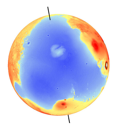
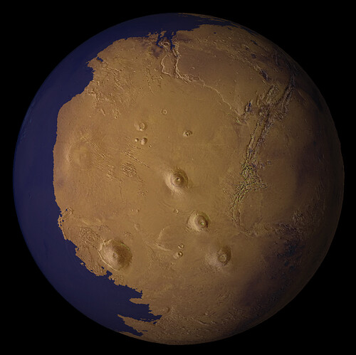
A view of Mars as it might have appeared more than 2 billion years ago, with
a low-latitude ocean filling the lowland basin that now occupies the north
polar region. Topographic deformation of features that ring the basin, which
are hypothesized to be shorelines formed by an ancient ocean, suggests that
Mars experienced significant true polar wander – reorientation of the
planet relative to its rotation axis – that brought the planet into its
present rotational state. The margins of the ocean shown here account for
the topographic deformation that would have resulted from this
reorientation. Sinuous features near the top of the image are valleys carved
by large floods that may have supplied the ocean water. The image was
generated using Viking Orbiter images and topographic data from the Mars
Orbiter Laser Altimeter on board the Mars Global Surveyor spacecraft.

Credit: Taylor Perron/UC Berkeley