Sono 15 anni dal lancio, anni e anni di immagini bellissime da Marte. Non è la sonda marziana più longeva ma è sicuramente quella che ha fornito i maggiori dettagli di tutta la superficie grazie a HIRISE, una fotocamera ad altissima risoluzione, che permette di individuare dallorbita anche i dust devil, le tracce dei rover, i leggerissimi cambiamenti della superficie.
Continua così MRO.
Alcune foto scelte nel link in cima al post.
E ora (finalmente) a guardare le foto di Hirise ci sarà anche l’intelligenza artificiale, molto utile per scoprire se è cambiato qualcosa sulla superficie tra una scansione e l’altra, ad esempio dovuto all’impatto con un meteorite.
Incuriosito da questo twitter multilingua (inglese, ceco, ungherese).
Ho seguito il qr code in basso a destra dell’immagine relativa al meteo e ho trovato questo bel video su youtube che mostra l’evoluzione climatica attorno al polo nord di Marte ripresa dallo strumento MARCI di MRO. La ricostruzione del timelapse è eseguita da un geologo planetario ungherese, Henrik Hargitai.
Le date sono espresse in anni marziani e Ls, longitudine solare, per vedere a cosa corrispondono potete fare riferimento alla pagina di planetary society: https://www.planetary.org/articles/mars-calendar
Grazie al lavoro di tanti volontari e grazie a una piccola percentuale del database dalle immagini di MRO, si è riusciti a individuare un particolare comportamento delle nuvole marziane.
Questo anche a sottolineare che la mole di dati che le sonde mandano a Terra è così ampia che chiunque può contribuire a fare ricerca.
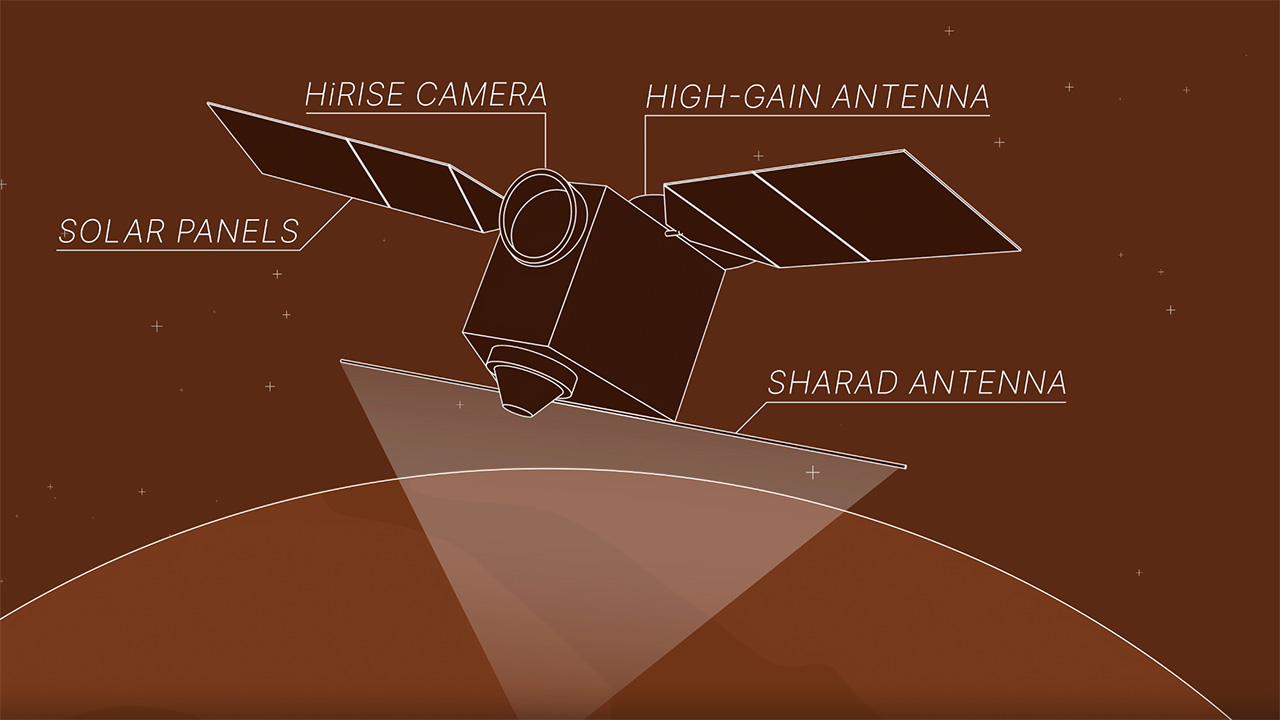
After nearly 20 years of operations, NASA’s Mars Reconnaissance Orbiter (MRO) is on a roll, performing a new maneuver to squeeze even more science out of the busy spacecraft as it circles the Red Planet. Engineers have essentially taught the probe to roll over so that it’s nearly upside down. Doing so enables MRO to look deeper underground as it searches for liquid and frozen water, among other things.
This illustration depicts NASA’s Mars Reconnaissance Orbiter, or MRO, flipping 120 degrees, completing what’s called a “very large roll.” This position can increase the capabilities of the spacecraft’s subsurface radar instrument, SHARAD, by 10 times or more, providing a clearer and deeper look below the Martian surface. NASA/JPL-Caltech
Throughout its mission, the Mars Reconnaissance Orbiter (MRO) has often rolled about its along-track axis by up to 28° to partially compensate for the suboptimal location of the Shallow Radar (SHARAD) antenna along an edge of the spacecraft that is opposite the imaging payload deck, thereby enhancing the signal-to-noise ratio (S/N) of echoes returned from the surface. After recent modeling work predicted that a much larger roll would improve the S/N by ~10 dB relative to nadir-pointed observing, MRO began a limited series of 120° roll maneuvers to test the effects on radar sounding. Three such SHARAD very-large-roll (VLR) observations were acquired between 2023 May and 2024 September, and they show dramatic improvements in signal clarity and depth of penetration, with S/N increasing by 9, 11, and 14 dB over that of nearly coincident observations at 0° roll angle.